The Hermit Loop
The Hermit Loop is a 4 or 5 day backpack offering a perfect sampling of everything the Grand Canyon has to offer. It can be done in 3 days but that would mean missing some of the best parts of this area. You’ll hike one of the rougher trails on the South side, have the opportunity to hike up idyllic side canyons alongside babbling streams, be able to spend the night on lovely Colorado River beaches, and spend a stunning day on the Tonto Platform. There are several variations on this trip. I’ll cover most of them in the route descriptions below. The maps and mileages show my favorite 4 day variations.
Logistics
The Trailheads – This is a point to point hike so you’ll need to get back to your car somehow. Fortunately Grand Canyon National Park can be very helpful with this problem. The Hermit Road Shuttle Bus can take you from one trailhead to the other at either the beginning or end of your hike. My recommendation is to park at the end of your hike and take the shuttle to your starting trailhead. You’ll be very tired at the end and won’t want to deal with catching a shuttle. Note the shuttle doesn’t run in December, January, or February.
This hike can be done east to west or vice-versa. Each route has pluses and minuses. If I had to choose I’d say east to west is the better choice but it is a great trip either way. The permit you get will probably decide which way you go (see Permits below).
If going east to west you’ll start at the Bright Angel trailhead. The Bright Angel trailhead is located right in the village next to the Bright Angel Lodge. You’ll want to drive out to Hermit’s Rest, the end of the hike, to drop off your car if you have one. Then take the shuttle back before you start the hike. Note that there is a gate at the beginning of the road to Hermit’s Rest. If you get a permit for the Hermit Trail it will contain a code to get you through this gate. The shuttle bus will drop you just steps from the Bright Angel. If you’re starting out at Hermit park at the Backcountry Information Center and do the 10 minute walk to the Hermit Shuttle. Take the shuttle out to Hermit’s Rest to start your hike.
Weather and When To Hike – Like most inner canyon hikes, this one is best done in the shoulder seasons: mid-March to mid-May and late September to mid-November. From mid-May to late September it is almost always brutally hot in the canyon (seriously life threatening hot) and there is very little shade on the Tonto. From late November to mid-March it can be pretty cold. There is often ice or snow on the upper parts of the Bright Angel and Hermit Trails. Plus the short days allow less time to see the majestic scenery you came to see.
Permits – This is a difficult permit to get. The route is very popular (for good reason) and there aren’t very many spots available. The best way to increase your chances of success is to list as many options as you can on your permit application. Here are the options I would list, in this order of preference. See the route description below for more details on each option. For a 4 day trip on the east to west itinerary your night 1 options are Horn Creek (dry) and Indian Garden. Listing Salt Creek (also dry) for night 1 will greatly increase your shot at the permit but that’s a 12 mile hike on day 1. On night 2 you probably want water available so try for Granite Rapid, Monument Creek, and Hermit Creek in that order. All have reliable water. So does Hermit Rapid but that’s a long walk, especially if you spent night 1 at Indian Garden. On night 3 Hermit Creek provides the shortest hike to the top but Monument Creek is also doable. Try not to stay on the Colorado at Hermit Rapid or especially Granite Rapid on the last night. It’s a very long trip to the top from the river.
The Route: East to West in 4 Days
| Miles | Elevation | Hours | |
| Day 1 (Bright Angel to Horn Creek) | 7.0 | -3920 +630 | 5-7 |
| Day 2 (Horn Creek to Monument Creek) | 7.8 | +1590 -2160 | 6-8 |
| Day 3 (Monument Creek to Hermit Creek) | 3.1 | +970 -1000 | 2-3 |
| Day 4 (Hermit Creek to Hermit’s Rest) | 7.0 | +5120 -1450 | 7-10 |
Map
Day 1
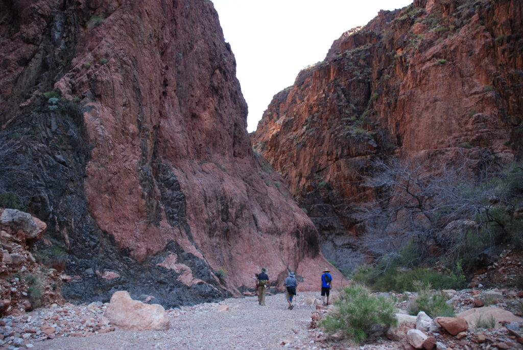
This hike starts at the most popular and crowded tralhead in Grand Canyon National Park, the Bright Angel Trailhead. You’ll have plenty of company as you start down. Don’t worry, It gets better. You’ll enjoy fantastic views of the Tonto Platform 3000 feet below you, Bright Angel Canyon on the other side of the (not visible) Colorado River, and the North Rim. The big patch of green trees far below you is your first destination: Indian Garden. Don’t miss the stunning pictograph panel up on your left just after the first tunnel. After the tunnel you’ll descend quickly along a couple long traverses, through a second tunnel, and down several switchbacks in the Coconino layer called Jacob’s Ladder. Although crowded, the trail is very well maintained and easy to walk. Make sure to give way to any mule trains that pass you. Stand on the uphill side of the trail and get as far off the trail as you can.
At 1.5 miles you’ll reach the first of 2 resthouses on the Bright Angel, called (not very creatively) 1.5 Mile Resthouse. Here there are fairly nice pit toilets and usually water. The water, though, is often shut off in the winter or due to pipe breaks. If you plan to rely on it check the bulletin board at the top for current status. After 1.5 Mile House the trail descends in a series of long switchbacks through the Hermit Shale and especially the Supai layers to your next destination: 3 Mile Resthouse. I won’t bother telling you how far down the trail you are at this point. Like 1.5 Mile House, 3 Mile House has fairly nice pit toilets and (not always reliable) water.
From here the trail continues its moderate descent through the Redwall, Muav, and Bright Angel Shale layers until you round a corner and finally flatten out a bit on top of the Tapeats layer. Your aching knees and toes will appreciate having mostly finished your descent for the day. From here it is a short walk to Indian Garden.
If you are staying the night at Indian Garden take your 2nd left (you should see some nice Cottonwoods next to the trail) and a quick right into the campground. Pick a site and make yourself at home for the night. My favorite sites are the first ones you come to from this direction. There’s also 2 nice spots up near the bathroom. They can be a little loud but the views from up there are very nice. If you are continuing on to Horn Creek stay on the main trail. You’ll come across one more set of pit toilets and (usually reliable) water here.
To continue on to Horn Creek walk past the bathrooms and water. Turn left just past the mule barn and cross Garden Creek. You’re now following the Plateau Point Trail. About 3/4 mile from Indian Garden you’ll reach the Plateau Point/Tonto West trail junction. If you are staying the night at Indian Garden or if you have the time, Plateau Point is very much worth the 1.5 mile round trip from here. It has a 360 degree view of the canyon rising all around you and a view down to the river 1,500 feet below. Sunset there is magical. To continue on to Horn Creek turn left.
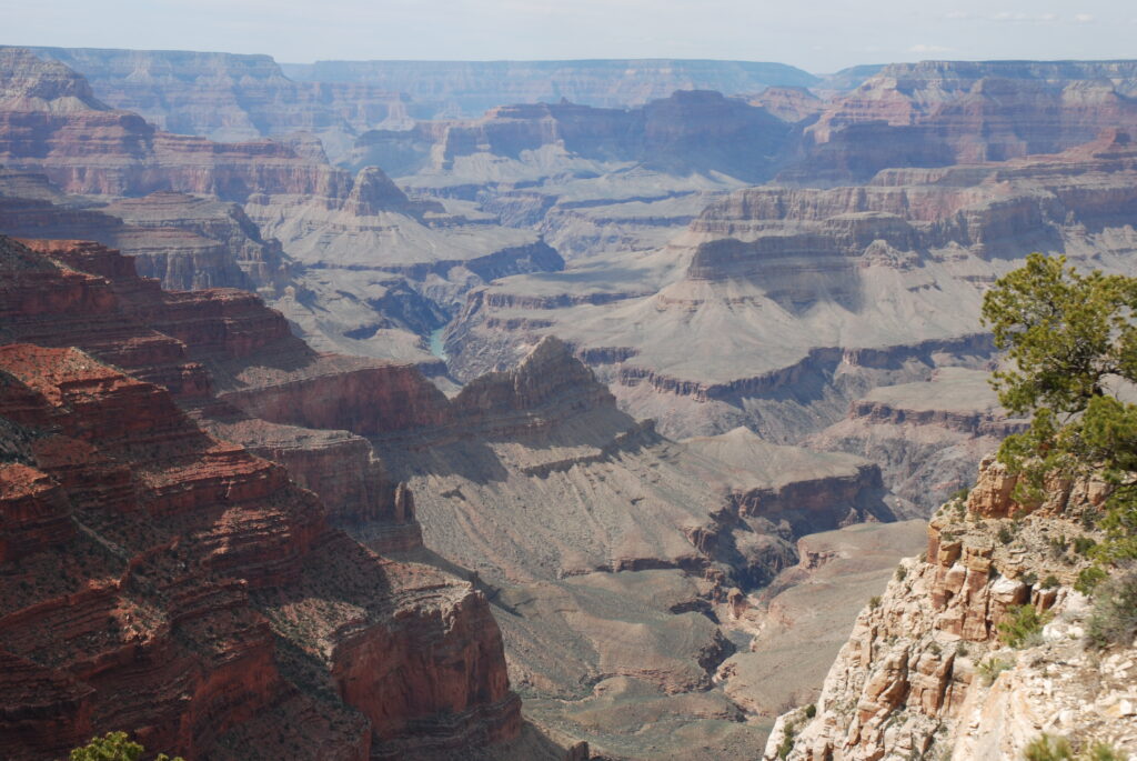
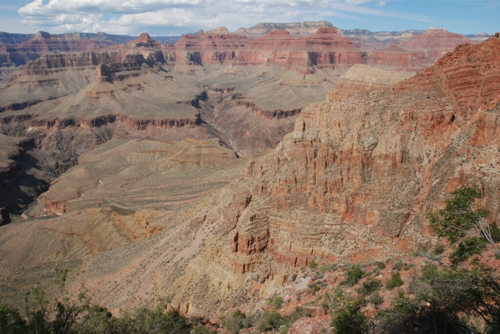
This is where you really leave civilization behind. You won’t see many (if any) other hikers as you make your way along the Tonto Trail heading west toward Horn Creek. The Tonto Trail is a +/-70 mile trail that winds its way along the Tonto Platform from Red Canyon in the east to Garnet Canyon in the west. Add in the Escalante, Beamer, and Royal Arch extensions and you have over 100 miles of mostly flat hiking deep inside the Grand Canyon. As lonely as the trail you are hiking is, this is probably the most used section of the Tonto.
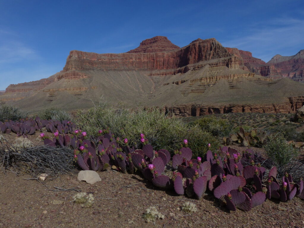
The terrain you are walking on is the top of the Tapetas formation. The vegetation this far down from the rim is mostly Mojave desert flora. You’ll see several varieties of cacti, rabbit brush, and the ubiquitous blackbrush. The beaver tail and prickly pear cactus blooms cover the Tonto in purple or yellow blooms in spring some years.
While mostly flat the Tonto can be very frustrating to hike. It goes nowhere in a straight line. You quickly get used to the pattern. You’ll be standing on an edge with a view of the Colorado below you looking across a side canyon at the trail maybe a few hundred yards away. To get there, though, you need to walk parallel to the side canyon until it rises to the level of the Tonto, cross it, then parallel it again back towards the river to get around the next point. Making a mile down river can take 3 or 4 miles of walking.
From the junction it is just over 2 mostly flat miles to Horn Creek. At Horn Creek you’ll find just one fairly small campsite right next to the creek bed. Note there is often water in this creek but the park recommends you do not drink it. They say don’t even use it to wash yourself or your dishes. The problem is the creek is contaminated by an old uranium mine upstream (legacy of the Cold War). You’ll want to tank up at Indian Garden with enough water to get you through your night at Horn and a full day of hiking the next day (maybe 4-6 liters per person). This is because your next reliable water is at Monument Creek over 7 miles away. There is also a bathrooms of a sort (big box with a seat on it) at Horn, although it can be a little difficult to find. It’s south of the trail a little way back up the trail toward Indian Garden from the camp site. One last note on Horn Creek; make absolutely sure your food and anything with an odor is in a rodent proof sack at night. Also maybe reconsider sleeping in the open here. The place is crawling with small mice. I’ve woken up in the middle of the night with one on my chest more than once.
Day 2
This is Tonto Trail Day. Whether you start from Indian Garden or Horn Creek, you’ll head west (downstream) along the Tonto. After Horn Creek you’ll round Dana Butte then head back toward the South Rim to cross Salt Creek. Salt is usually complnetely or mostly dry, and if there is water in it it’s usually pretty nasty. Note there is a camp site here that can be an option when applying for your permit. Next comes a large line of cliffs called The Inferno then it’s head away from the river again to Cedar Spring (usually dry). Cedar Spring is also a cam site option. As you make your way along this section the views of the South Rim are spectacular and the views orth are even better. Take a look at the ever-changing panorama to the north as you pass Cheops Pyramid, Isis Temple, Shiva Temple, Tower of Set, Horus Temple and Osiris Temple.
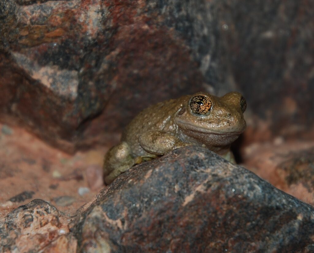
About 1.25 miles past Cedar Spring the trail descends down a couple easy switchbacks to Monument Creek. As soon as the trail crosses the creek you reach the Monument Creek campground. There are 3 or 4 sites here with several large cottonwood trees. If you’d like a beautiful shady overhang to hang out under, go through the first campsite on the left toward the low cliff. It’s a great spot. The larger group site is a little further along, above the trail on the left, past the toilets. Monument Creek may be dry where you cross it just before the campground but it comes above ground reliably just downstream. To find reliable water go through the campground and walk another couple hundred yards down the trail. Look for the side trail and the sign on the right just past the toilets. I’ve always thought this spot where Monument Creek comes briefly to the surface is particularly lovely. The stream has polished some beautiful Zoroaster Granite perfectly smooth. Also, look for hundreds of tiny frogs hanging out and enjoying the water here. If you like it quiet when you sleep bring earplugs. The frogs are pretty noisy for how small they are! To me Monument Creek is one of the nicest camping spots in the canyon. You’ll most likely have a little company but count yourself lucky if you get a permit to camp here.
The only problem is that camping down on the Colorado at Granite Rapid might be even better. If you’re headed down there (or if you have time to do a day hike down there) continue past the toilets and group camp site toward the now visible Monument. This 130 foot high pillar of Zoroaster Granite and Tapetas Sandstone lies just downstream from the group campsite at the junction of the trail down to the river.
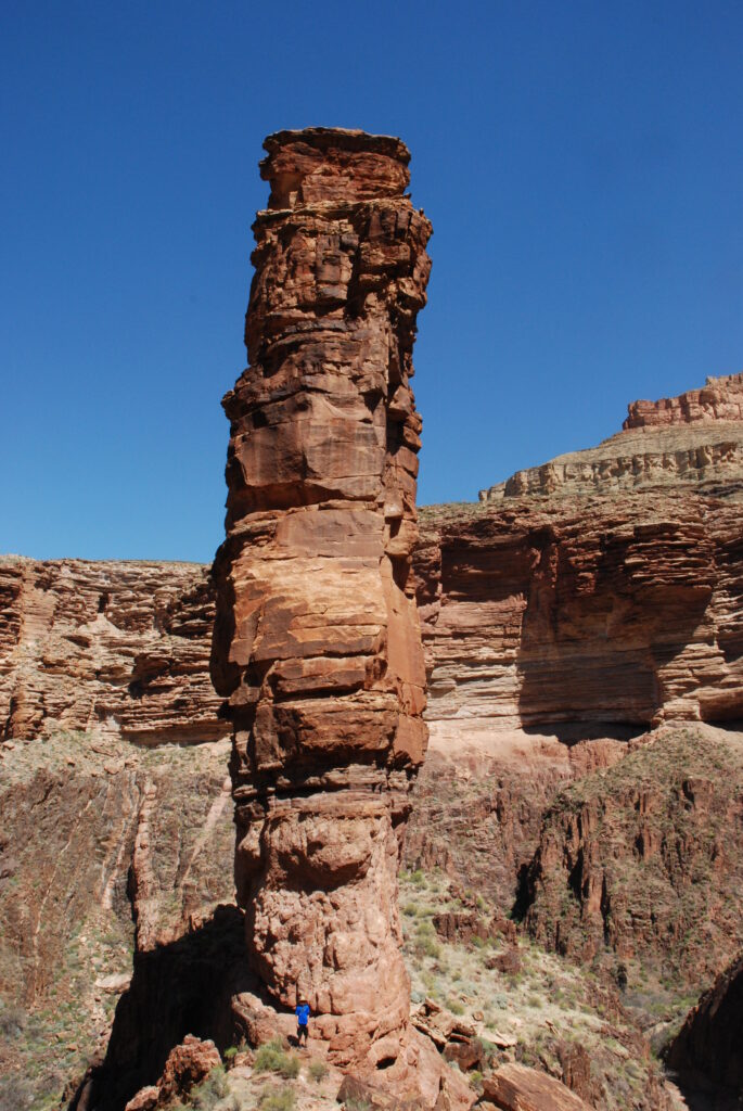
After taking a minute to gaze up at the Monument (and wonder how on earth it can stand there like that), turn right at the junction to head down to the river. The short descent to the bottom of Monument Canyon here is pretty rough and slippery, as is the first 1/4 mile or so when you get to the bottom. Take your time. One navigation note, the descent down next to the Monument puts you maybe 100 yards up a little side canyon. When you hit the main canyon turn around a look behind you. When you come back up from the river this turn isn’t obvious. If you miss the turn you’ll dead end at a cliff a little further up the main canyon so you can’t really get lost. Shortly after you enter the main canyon you’ll end up on loose gravel and stay on it for most of the 1.3 miles to the Colorado. There isn’t really a trail here, just follow the canyon. Take some time to check out the rocks in the canyon. There’s beautiful water-polished rocks from every layer of the canyon down here.
You’ll hear the river before you see it but it will come into sight soon enough. The best camping down here is a lovely beach upstream from the stream bed. You’ll see the trails heading upstream through the tamarisk. Follow them until the cliff reaches the river. This is one of my favorite camping spots in the Grand Canyon. It’s a lovely beach with the river right there and a beautiful cliff of Zoroaster Granite and Vishnu Schist just behind you. The only problem with it is that river trips like it, too. You may find 20 or 30 people and 3 or 4 rafts there already. If so, make your way back downstream. Cross Monument Creek and head to the far downstream end of the beach. There’s less shade here and it’s a little noisier from the rapid but there’s some nice flat spots down here as well.
Day 3
If you spent night 2 down at Granite Rapid, retrace your steps up the canyon 1.3 miles to the junction under the Monument and turn right. Remember not to miss the right hand turn into the little side canyon just before you reach the junction. If you spent the night at Monument Creek, continue along the path past the toilets and the group camp site to the junction under the Monument. Turn left. From here it’s a rough 3/10s of a mile along the bottom and up out of Monument Canyon. Once you get out of the canyon back onto the Tonto Platform the trail flattens out again and becomes much less rough. You can make good time covering the 1.8 miles around Cope Point to the junction with the Hermit Trail. After you round the point the views of the Colorado down in Granite Gorge are fantastic but you may want to keep your eyes on your feet. The exposure here is a little intimidating for some people. At the Hermit Trail junction turn right. While you’re there you may or may not want to look left up the hill. You’ll be climbing that the next day.
From the junction it’s an easy 1.1 miles through the dramatic Hermit Basin to the Hermit Creek camping area. For the best campsite stay right as you pass the toilets. The site up next to the cliff stays shady most of the day. The rest of the sites have a much less shade.
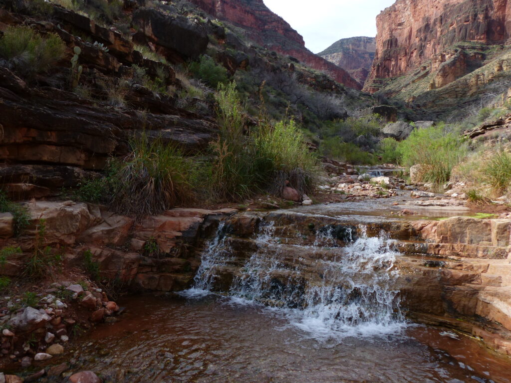
The campsites here are a little bit on top of each other but Hermit Creek makes up for it in other ways. First is Hermit Creek itself. It’s a little gem and absolutely reliable for water. If you have time, do the easy 2.6 mile round trip down to the Colorado and back. Or, for a shorter day hike, wandering a mile or so upstream along the creek is also very rewarding. Either direction you’ll pass little pour-offs and beautiful polished rock with the walls of the upper canyon towering above you. If you plan to hang out around camp there is a great spot just a few hundred yard downstream from the camp. The canyon is narrow here so there’s always shade. Plus the canyon bottom is very smooth so there’s plenty of space to hang out and take a dip in the creek. Also, I would be remiss if I didn’t mention the toilets at Hermit Creek camp. The park put in new composting toilets here around 2018. They’re pit toilets but they’re just about the nicest pit toilets you’ll ever use.
Day 4
Wherever you start from this last day of the Hermit Loop is a long, challenging day. If you’re at Monument Creek, follow the trail past the toilets and the group campsite down canyon toward the Monument. When you reach the base of the Monument turn left to follow the trail up a side canyon. The section up the side canyon is pretty rough but the trail ascends up out of the Monument Canyon fairly quickly. Once back up on the Tonto Platform the trail improves dramatically and you can start making good time. From here it’s a nice easy and lovely 1.8 miles around Cope Point to the Tonto/Hermit junction. Once you pass Cope Point the views down to the Colorado are fantastic. The exposure here will get your attention but it’s not too bad for the Grand Canyon.
If you start this day at Hermit Creek You have a little less distance to cover before the climbing begins. Retrace your steps the few feet from the campground up past the bathrooms to the Tonto Trail and turn left. You’ll cover the flat, easy 0.8 miles past the ruins of Hermit Camp to the Tonto/Hermit junction pretty quickly.
The Tonto/Hermit junction is where the work begins. First comes a steady of 1,000 feet in just 0.9 miles through the Bright Angel Shale and Muav formations to the base of the Redwall. As you ascend the views out over the Hermit Basin and downstream in the main canyon get better and better. When you hit the Redwall you start up the Cathedral Stairs, one of the steeper sections of the trail. It’s only 0.2 miles but you climb almost 400 feet in that short distance.
Once you top out on the Cathedral stairs you start to lose the views down into Hermit Basin but you get somewhat of an extended break. The next section, called the Supai Traverse, is a long section of alternating short climbs and flat traverses. The trail here is mostly pretty good but there are a few sections that have been wiped out by rockslides. In these sections just look for the cairns. They’re generally marked pretty well and they’re not very long. Footing can be an issue in the rockslide sections so tread carefully. Expect to climb about 900 feet over this 3.4 miles section.
The Supai Traverse ends by popping you up into a lovely little valley at the head of Hermit Canyon where you’ll quickly reach the junction with the Dripping Springs and Boucher Trails. Keep going straight ahead and enjoy the last little bit of flat trail as you cross the valley. As you reach the other side you start climbing again. You’ll pass the Waldron Trail on your right then climb steeply up though the Coconino, Toroweap, and Kaibab layers. Keep an eye out for the fossilized reptile tracks on your right when your climbing the cobblestone chunk. It’s only 1.2 miles from the Waldron junction to the top but you’ll climb over 1200 feet in that short distance. With altitude becoming a factor as well I promise you’ll be breathing hard by the time you reach the top. Be sure to check out the nearby Hermit’s Rest store for a well-earned ice cream (and to see the cool architecture). If you parked back in Grand Canyon village the shuttle bus stop is just past the store about 0.2 miles from the trailhead.